A storm of records
In January 2020 a low pressure system originated in the North Atlantic and developed into a rain and wind storm the Western Mediterranean. It was named Gloria on the 18th January by the Spanish National Meteorological Agency (AEMET). It affected areas of Spain, France, Morocco and Portugal, but Eastern Spain and Southern France were particularly hit. In Spain, the storm killed at least 13 people due to flooding, mudslides, flying objects and hypothermia.
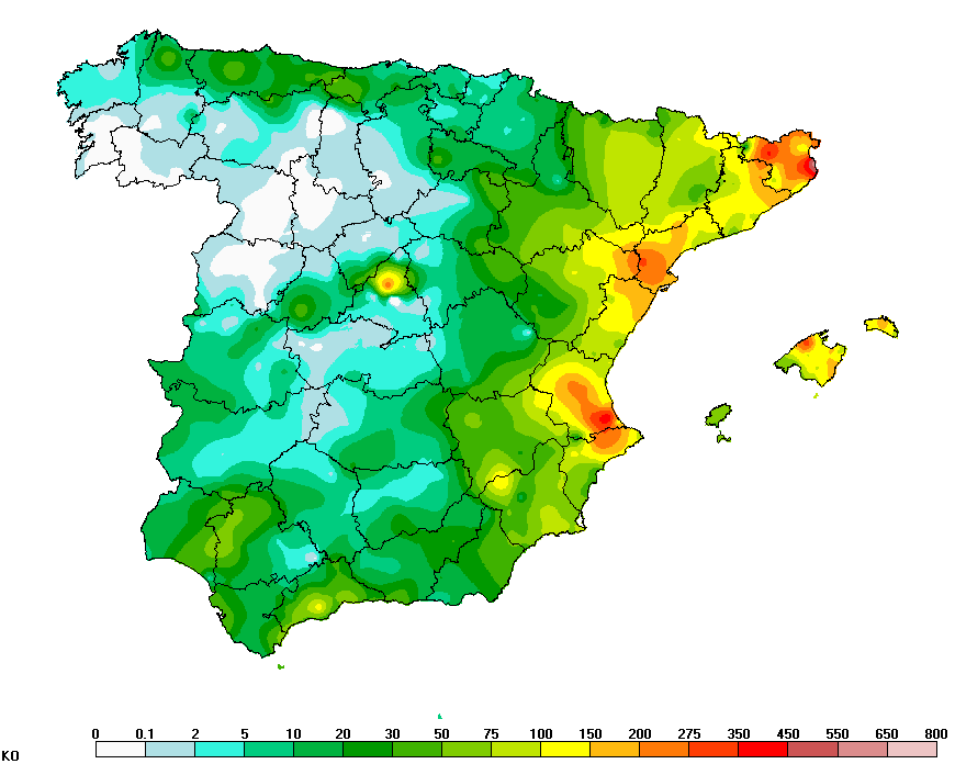
The storm generated heavy rainfall rates and very high winds that broke multiple records (AEMET). For example, in Mallorca (Balearic Islands), wind speed measurements reached 110 km/h and stations in mainland Spain recorded wind speeds up to 133 km/h (Puerto de Leitariegos, Asturias). In Catalonia, Valencian Region, Murcia and Andalusia saw record-breaking rainfall totals. Total precipitation during the event exceeded 300 mm in seven different stations and the maximum total was recorded at Barx (Valencia) with a highest total of 433 mm. Other precipitation records include 24-h accumulated rainfall of 224.4 mm (Horta de San Joan, Tarragona) and multiple 24-h records above 150 mm. Heavy snowfall and blizzards were also highly impactful and the snow level dropped to 300 m.a.s.l. In Villafranca (Castellón), 86 cm of snow fell over 24h, setting a new record in Spain, which previously stood at 80 cm at the same location and dated back to 1968.
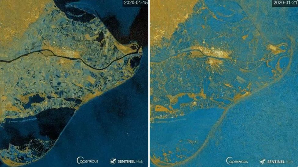
Weather conditions also generated a storm surge in the westernmost part of the Mediterranean Sea that caused severe flooding (Amores et al. 2020), sometimes combined with floods from heavy rainfall on land. The Ebro river delta was especially affected and large areas of the delta were swept up.
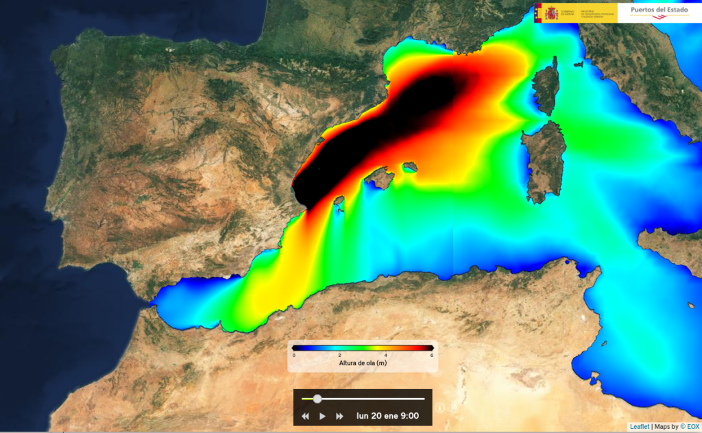
The largest significant wave height in recorded history in the Mediterranean Sea was measured at the buoy off the coast of Valencia. Storm Gloria generated a record-breaking significant wave height of 8.44 m, which surpassed the previous record for the entire Mediterranean set in Mahon (Menorca) at 8.15m.
This is not the maximum wave height but the mean height of the highest third of any wave set. In fact, near Dragonera (an island off Mallorca), a buoy detected a maximum wave height of 14.2m during Storm Gloria.
The storm produced an intense lightning activity. In the eastern coast of Spain, a total of 3035 strikes were recorded during one day (21st Jan), which is the highest ever (since 1990) count for the Valencian region over a day.
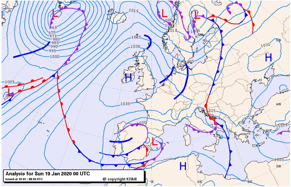
Storm evolution
According to AEMET, a vortex in the upper levels of the atmosphere that generated in the North Atlantic moved towards the east while a low pressure system began to build in the lower levels. The system entered through the Bay of Biscay and landed on the Iberian Peninsula on the 18th January 2020. It was yet a weak cyclone that crossed the Iberian Peninsula and met the the Western Mediterranean, where it slowly deepened and got its name Gloria. It remained in the region for a few days but it never became a very deep low. It was rather the presence of a very high pressure system over the British Islands that caused a strong pressure gradient from France to the Balearic Islands. The strong winds that resulted from the gradient generated an intense swell that progressively turned to the west and impacted the eastern coast of Spain. In this process, the center of the system moved south towards the Alboran Sea, where it was absorbed by a larger low-pressure system. This new merged system continued to affect the eastern coast of Spain but the impacted regions where shifting south. The storm remained very active for the next days and produced new convective episodes with significant rainfall rates and hail. The low-pressure system moved to the east in the 26th Jan and dissipated.
Overall, Storm Gloria and the subsequent system supplied with large moisture amounts and produced extreme precipitation events in the Balearic Islands and the eastern mainland. The storm generated three main nuclei of intense precipitation. First over the the eastern end of the Baetic Mountain range, and then over Mediterranean facing sections of the Iberian System and the Pyrenees.
Storm simulation and visualisation
We simulated the weather conditions over the Western Mediterranean during the period 17-25 January 2020. We used the Weather Research and Forecasting (WRF) model version 4.3.1 at 4km spatial resolution and driven by ERA5 reanalysis from the ECMWF. The model outputs were processed to load them in Paraview 5.10, a 3-D visualization software. The video below shows the storm Gloria evolution over the region with focus on precipitation and wind.
The maximum accumulated precipitation totals over the three nuclei are highlighted in the end. The total maximum was registered over the Pyrenees, where a total of 545 mm where simulated. This was also the region where AEMET estimated the highest amounts. The maximum wind speed in the model over the western Mediterranean was ~ 115 km/h. All this simulated values are comparable to estimated records from observations. This kind of videos provide an innovative perspective on meteorological events and the visualization above helps understand the dynamics of the Storm Gloria and the sequence of impacts in the region.
References
Amores, A., M. Marcos, D. S. Carrió and L. Gómez-Pujol. Coastal impacts of Storm Gloria (January 2020) over the
north-western Mediterranean. Nat. Hazards Earth Syst. Sci. 20, 1955-1968, 2020. https://doi.org/10.5194/nhess-20-1955-2020