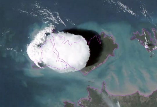
Hector is a convective storm that develops over the Tiwi Islands, in Northern Territory (Australia), offshore Darwin. It forms so regularly that it has earned its own name, given by pilots during the Second World War. It occurs almost daily during the wet season (September to March).
The video below by the Australian Bureau of Meteorology is an amazing example of the development of Hector during an event in November 2019.
Hector forms in the early afternoon and reaches its peak between 15-17H and dissipates in the evening. It is originated by sea breeze, which is a circulation pattern produced by differences in temperature between the ocean and the land. When sea breeze fronts meet at the center of the Tiwi Islands, they force air to rise and the water vapour held in the air condenses producing this beautiful cumulonimbus.
Hector in convection-permitting models
These convective processes represent a great challenge for most models. They are generally very localised and are originated by fine-scale mechanisms often poorly resolved by atmospheric models running at typical spatial resolutions (>10 km). Thus convective processes are incorporated into models through so-called parameterisations, which are semi-empirical approximations aimed at representing when convection occurs and what is its impact on the atmosphere. They have very proven useful for many applications, but have also been attributed errors in the representation rainfall features.
Next-generation models are running at high enough resolutions (< 4 km) to represent very fine-scale mechanisms, such as those generating and developing convective cells. They are known as convection-permitting or convection-resolving models because they represent most convective processes explicitly making convective parameterisation no longer necessary.
Multiple studies have shown that convection-permitting models represent a conceptual step forward in atmospheric modelling and they bring significant improvements in the representation of rainfall, particularly in the tropics.
As part of the REHIPRE project, aimed at advancing our understanding of convection in the Maritime Continent, we investigated the impact of explicitly resolving convection on a series of precipitation features, such as the diurnal cycle (Argüeso et al. 2019). We also examined how convection-permitting models represent Hector much more realistically. A three-dimensional visualisation of clouds in the region as simulated by the convection-permitting model shows the recurrence of Hector over a period of 9 days (14 Feb 2016 to 22 Feb 2016).
A comparison between experiments with and without convection parameterisation helps determine differences in the realism of convective processes. The video below shows the evolution of Hector through a period of ten days as represented by a convection-permitting model at 2 km (top) and the same model using a convective parameterisation. In particular, it shows the cloud cover and precipitation (left) and winds and cloud fraction along a transect that crosses Tiwi Islands.
The experiment resolving convection explicitly is qualitatively much closer to observations in the timing and shape of the Hector cumulonimbus that develops over Tiwi Islands. The vertical structure of clouds is also closer to the classical depiction of cumulonimbus clouds with the anvil dome at the top. In fact, the experiments using convective scheme is unable to produce Hector in most cases, which indicates its limitations in representing fine-scale convective cells.
These results emphasise the potential of convection-permitting models for better representing the physical processes generating rainfall and thus for a more realistic simulation of tropical precipitation.

Recent Comments